Guest post by Katherine York, a photographer based in Berlin, Germany, specializing in architectural and ethnographic landscape photography. Katherine documents minimalist landscapes containing current social and political issues and their remnants that appear to be ignored or forgotten. She's dedicated to her continued research of the United States-Mexican infrastructure, borderlands, and personal projects. Katherine's work can be viewed on her website, Studio York.
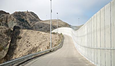
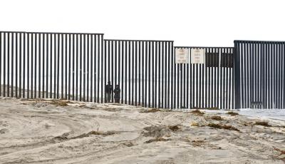
In 2011/12, I was granted access to document conceivably the most significant and debated stretch of the US-Mexico border, capturing several zones that are now closed indefinitely to non US government employees. In the beginning of the 20th century, a simple line was initially enforced to mark the divide, followed by a wire and then, a fence. Nearing the end of the century, for many residents, the border had expanded into a wall. In 2006, US Congress passed the Secure Fence Act, instructing the Department of Homeland Security to provide for at least two layers of reinforced fencing, the installation of additional physical barriers, roads, lighting, cameras, and sensors through 1,200 km of the US-Mexico borderlands. Under the force of the 2005 REAL ID Act, Homeland Security was allowed to waive regulations, acts, and laws, as well as pursue construction without publicizing plans or public comment periods, thus making the precise location and construction of the fencing difficult for the public to ascertain. Patchworks of physical barriers and fences have been erected through remote deserts, mountains, urban streetscapes, and sand dunes, eventually plummeting into the Pacific Ocean, thereby redirecting migrants into harsher desert conditions, resulting in an insurmountable rise of migrant deaths. These new spatialities of sovereign power in the US are having significant impacts, dramatically reconfiguring the land, the natural movement of wildlife, nature, and water, as well as the relationships between law, federal government, its citizens, and neighboring country of Mexico. As continued bills are passed, laws created, politicians seize more power. In 2013, when discussing the projected goals of the US-Mexico border, Senator John McCain stated: “We'll be the most militarized border since the fall of the Berlin Wall.”
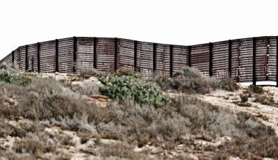
LANDING MAT Re-purposed from raw military material, this corrugated steel was once used as portable touchdown pads for helicopters operating in Vietnam. The panels are about 3.5 m long, 50 cm wide and 6 mm thick, welded to steel pipes buried 2.5 m deep, typically standing 3 m tall. 1.6 km of fencing requires 3,080 panels costing about US$5,000 to erect. Landing Mat is the oldest and most common border fence still in use in every border state except Texas. Incidentally, agents cannot see the possible dangers on the Mexican side and are frequently attacked by rock throwers. The US Border Patrol often cut holes into lower segments of the fence, to help reveal if someone is directly on the other side. Because of its inefficiency, Landing Mat is high on the list for replacement and/or additional fencing.
Any thoughts on this post? Get in touch with us! Send us an email, or post a comment here or on Facebook. You can also tweet us.
__________
How to cite this blog post (Harvard style):
York, K. (2015) Border Infrastructure: Photographing the US-Mexico Border. Available at: http://bordercriminologies.law.ox.ac.uk/border-infrastructure-fortifying-the-us-mexico-border/ (Accessed [date]).
Share:
With the support of